


The Five Climate Zones of Kilimanjaro: From Rainforest to Arctic Summit
Explore Kilimanjaro’s five climate zones, including their elevations, plants, wildlife, weather, trail conditions and clothing requirements.

Kilimanjaro’s Five Climate Zones at a Glance
Climbing Mount Kilimanjaro is often described as walking from the tropics to the Arctic in less than a week. That comparison is not merely poetic. From the cultivated lower slopes to Uhuru Peak at 5,895 metres (19,341 feet), the mountain passes through five strikingly different environmental zones.
You may begin among banana and coffee farms, enter a humid forest dripping with moss, emerge into giant heather and unusual high-altitude plants, cross a dry volcanic desert and finish among rock, snow and glaciers. Each zone changes the scenery, weather, trail surface, wildlife, clothing requirements and way your body feels.
UNESCO identifies Kilimanjaro’s five main vegetation zones as the lower slopes, montane forest, heath and moorland, alpine desert and summit. Trekkers commonly call them climate zones because each has a recognisable combination of temperature, moisture, wind, plants and terrain.
The boundaries are not rigid. They shift with slope direction, local rainfall, terrain and human land use. A route on the wetter southern side does not look identical to one on the drier northern side, and the landscape changes gradually rather than at a painted line. The elevation bands in this guide are therefore useful planning ranges, not exact scientific borders.
| Zone | Approximate elevation | Landscape | Typical conditions | Main trekking consideration |
|---|---|---|---|---|
| 1. Cultivated lower slopes | 800–1,800 m | Farms, villages, grassland and remnant woodland | Warm, often humid, with sun and seasonal rain | Heat, sun protection and arriving prepared |
| 2. Montane rainforest | 1,800–2,800 m | Dense forest, ferns, moss, vines and tall trees | Mild to warm, humid and frequently wet | Mud, slippery roots and keeping clothing dry |
| 3. Heath and moorland | 2,800–4,000 m | Giant heather, grasses, shrubs, lobelias and groundsels | Cooler, exposed and changeable, with strong sun and cloud | Layering, wind protection and emerging altitude effects |
| 4. Alpine desert | 4,000–5,000 m | Volcanic rock, dust, scree and very sparse vegetation | Dry, windy and sunny by day; often below freezing at night | Cold, UV exposure, fatigue and low oxygen pressure |
| 5. Arctic summit | 5,000–5,895 m | Bare rock, ice, snow and glaciers | Severe cold, wind and extreme altitude | Complete summit clothing, slow movement and safety monitoring |
These elevations overlap because Kilimanjaro is not ecologically uniform. Temperature, rainfall, soil and exposure can create pockets of one habitat above or below its usual range.
Why One Mountain Has So Many Environments
Kilimanjaro stands close to the equator, but its summit rises almost six vertical kilometres above sea level. Air pressure and temperature generally decrease with altitude, so climbing the mountain produces an environmental change similar to travelling thousands of kilometres away from the tropics.
Several forces shape its zones:
- Altitude: Higher air expands and cools, producing progressively colder conditions.
- Moisture: Air rising against the mountain cools and can form cloud and rain. Some slopes receive more moisture than others.
- Slope direction: Southern and south-eastern slopes are generally wetter, while the northern side lies in a drier rain-shadow environment.
- Sun and wind exposure: Open upper slopes receive intense ultraviolet radiation and have little protection from wind.
- Soil and volcanic terrain: Lava, ash, scree and young rock support different plant communities from deep forest soil.
- Human activity: Farming and settlement have transformed much of the lower slopes, while the national park protects higher natural habitats.
The result is not five sealed rooms. It is a continuous transition in which forest trees gradually become shorter, heather gives way to low cushions and lichens, and eventually almost all visible plant life disappears.
Zone 1: Cultivated Lower Slopes
Approximate elevation: 800–1,800 metres
Environment: Warm foothills, farms, villages, grassland and cultivated woodland
Most visitors first meet Kilimanjaro through its lower slopes around Moshi and the surrounding communities. This zone supports the people who live around the mountain and is an important part of the wider Kilimanjaro landscape, even though much of it lies outside the national park.
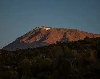
The deep volcanic soils and relatively reliable rainfall support crops such as coffee, bananas, maize, beans and vegetables. Traditional home gardens can combine tall shade trees, banana plants, coffee bushes and food crops in several layers. On clear mornings, the cultivated green foothills may sit beneath a distant white summit—a dramatic reminder of the vertical journey ahead.
What the Lower Slopes Feel Like
Conditions are usually warm and may be humid. Midday sun can be strong, while cloud and rain may develop depending on the season and side of the mountain. Moshi sits at a lower elevation than the main gates, so the air generally becomes cooler as the vehicle climbs towards the trailhead.
This is not normally a full trekking day on most itineraries. Climbers travel through the zone by road before beginning at a gate close to the forest. Nevertheless, it matters operationally: this is where equipment is checked, bags are organised, permits are processed and the team prepares to enter the park.
Plants, Wildlife and People
The landscape is largely shaped by agriculture and settlement. Shade trees, fruit trees and planted crops are more conspicuous than the undisturbed natural vegetation that once occupied broader parts of the foothills.
Birdlife can be rich, and small mammals may occur where farms meet woodland. Larger wildlife is not a normal expectation in settled areas. The most important story here is the relationship between the mountain and the communities that depend on its soil, forests and water.
What to Wear
- Lightweight, moisture-wicking trekking clothing
- Sun hat, sunglasses and sunscreen
- Broken-in waterproof hiking boots
- Rain jacket within easy reach
- Light fleece available for a cool or wet trailhead
Avoid dressing for summit temperatures at the gate. Overheating creates sweat, and wet base layers can later make you cold.
Zone 2: Montane Rainforest
Approximate elevation: 1,800–2,800 metres
Environment: Dense, humid mountain forest
The rainforest is the first major natural environment encountered on most routes. Tall trees form a canopy above ferns, mosses, lichens, vines and shade-loving plants. Moist air, filtered light and the smell of wet earth make this zone feel completely separate from the farmland below.
UNESCO describes Kilimanjaro as encircled by montane forest and notes that the mountain supports numerous mammals, including threatened species. The forest belt also performs an essential ecological function by intercepting mist and rain, storing water and protecting soil.
Why Some Routes Look Wetter Than Others
The Machame, Umbwe and Lemosho approaches generally enter moist forest on the southern or western side. Trails can be muddy, particularly after rain. Rongai begins on the drier northern side, where the forest may feel more open and rainfall is often lower.
Marangu passes through a lush south-eastern forest. No route, however, has guaranteed weather. A supposedly dry season can still produce rain, and a drier approach can still become wet.
What Climbers See
Vegetation varies around the mountain, but the experience may include:
- Tall evergreen forest trees
- Tree ferns and ground ferns
- Moss-covered trunks and branches
- Lichens, vines and epiphytes
- Small streams and wet gullies
- Dense undergrowth beside the trail
Blue monkeys and black-and-white colobus monkeys are among the animals climbers may see or hear in forested areas. Duikers, bushbuck, buffalo, elephants and other mammals occur within the wider Kilimanjaro ecosystem, but many are elusive, avoid busy trails or occupy parts of the park away from standard climbing routes.
Kilimanjaro is not a safari trail. Wildlife sightings should be treated as a welcome possibility, not promised as part of a climb.
Trail Conditions and Clothing
Forest paths may contain mud, standing water, wet roots, uneven volcanic stones and slippery sections. Trekking poles improve balance, while gaiters help keep mud and water out of boots.
Wear quick-drying trekking clothes and waterproof boots. Keep a waterproof jacket and overtrousers accessible, and protect the contents of your daypack with dry bags or a liner. Rainforest warmth can tempt climbers to delay putting on waterproofs; protect insulation and dry camp clothing before they become soaked.
Zone 3: Heath and Moorland
Approximate elevation: 2,800–4,000 metres
Environment: Open heath, grasses, shrubs and distinctive Afro-alpine plants
The transition out of the forest is one of Kilimanjaro’s most memorable changes. Trees become shorter and more twisted, views open across the mountain and the sky suddenly feels much larger. Giant heathers may form dense stands before giving way to broader moorland.
Cloud can rise from the forest during the afternoon and cover the trail. When it clears, climbers may see Kibo, Mawenzi, the Shira Plateau or the plains far below, depending on the route.
Plants Built for High-Altitude Stress
Conditions here are harsher than in the forest. Plants must tolerate cold nights, strong sunlight, wind, seasonal dryness and large temperature changes.
Characteristic vegetation may include:
- Giant heather and low heather shrubs
- Tussock grasses
- Everlasting flowers
- Proteas and other hardy shrubs at lower elevations
- Giant lobelias in suitable moist areas
- Giant groundsels, particularly around wetter valleys and sheltered drainage lines
Giant lobelias and groundsels are iconic East African high-mountain plants. Their rosettes, insulating dead leaves and specialised forms help protect vulnerable tissues against intense daytime radiation and freezing nights. They are not evenly distributed across every route.
Weather and Altitude
This zone is a lesson in rapid change. A bright, warm morning can turn windy and cold when cloud forms. After sunset, exposed camps lose heat quickly. Strong sunshine remains possible even when the air feels cool, and ultraviolet exposure increases with altitude.
Many climbers first become consciously aware of altitude in this band. Breathing feels harder on hills, pace slows and sleep may become lighter. A headache, nausea, dizziness or unusual fatigue following an altitude gain must be reported to the guide.
The scenery does not determine altitude risk. Even a warm, sunny day can coincide with poor acclimatisation. Climbers should continue at a controlled “pole pole” pace, drink normally, eat regularly and answer health-check questions honestly.
What to Wear
- Moisture-wicking base or trekking layer
- Fleece or breathable mid-layer
- Waterproof and windproof shell
- Hiking trousers, with thermal leggings available
- Sun hat and high-quality sunglasses
- Warm hat and light gloves within reach
- Insulated jacket for camp and longer stops
Zone 4: Alpine Desert
Approximate elevation: 4,000–5,000 metres
Environment: Exposed volcanic terrain with very sparse vegetation
Above the moorland, plants become progressively smaller and farther apart. The landscape opens into an alpine desert of lava ridges, ash, boulders, dust and scree. Water is limited, soils are poorly developed and daily temperature swings can be severe.
The term “desert” describes the lack of moisture and vegetation, not constant heat. In direct equatorial sunshine, a sheltered slope can feel warm. When cloud covers the sun or wind crosses an exposed ridge, the same place may feel bitterly cold. Nights commonly fall below freezing.
What Survives Here
Plant life is limited but not entirely absent. Depending on elevation and local shelter, climbers may see low everlasting flowers, small grasses and sedges, mosses, lichens and compact cushion-like plants. Higher up, even these become scarce.
Routes cross different parts of this zone. Familiar features include the Shira Plateau, Lava Tower, upper approaches to Kibo and the rugged surroundings of Mawenzi. Barafu, Kibo Hut and School Hut sit high on the mountain in exposed terrain near the transition towards the summit environment.
Trail and Physical Conditions
The ground may consist of dusty paths, loose scree, rough lava rock and steep slopes without shade. Wind can lift dust, while strong sunshine creates glare. Covering the neck and using lip balm with SPF are as important as sunglasses.
At 4,000 metres and above, reduced oxygen pressure is impossible to ignore. Walking slows, appetite may decline and small tasks require more effort. Climbers may feel cold more easily because they are moving slowly and producing less heat.
Do not treat headache, vomiting, unusual weakness, confusion, poor balance or breathlessness at rest as normal discomfort. Report symptoms immediately. Clothing, fitness and determination cannot correct dangerous altitude illness; when necessary, the correct treatment is descent.
What to Wear
- Thermal or wicking base layer
- Fleece mid-layer
- Insulated jacket
- Windproof and waterproof outer shell
- Trekking trousers with thermal leggings as required
- Warm hat, neck gaiter and gloves
- Sunglasses with strong UV protection
- Sunscreen and SPF lip balm
Zone 5: Arctic Summit
Approximate elevation: 5,000–5,895 metres
Environment: Bare rock, ice, snow and glaciers at extreme altitude
The summit zone begins where almost all plant life disappears. It is commonly called “arctic” because of its cold, barren character, although Kilimanjaro remains close to the equator and does not share the Arctic region’s seasonal daylight pattern.
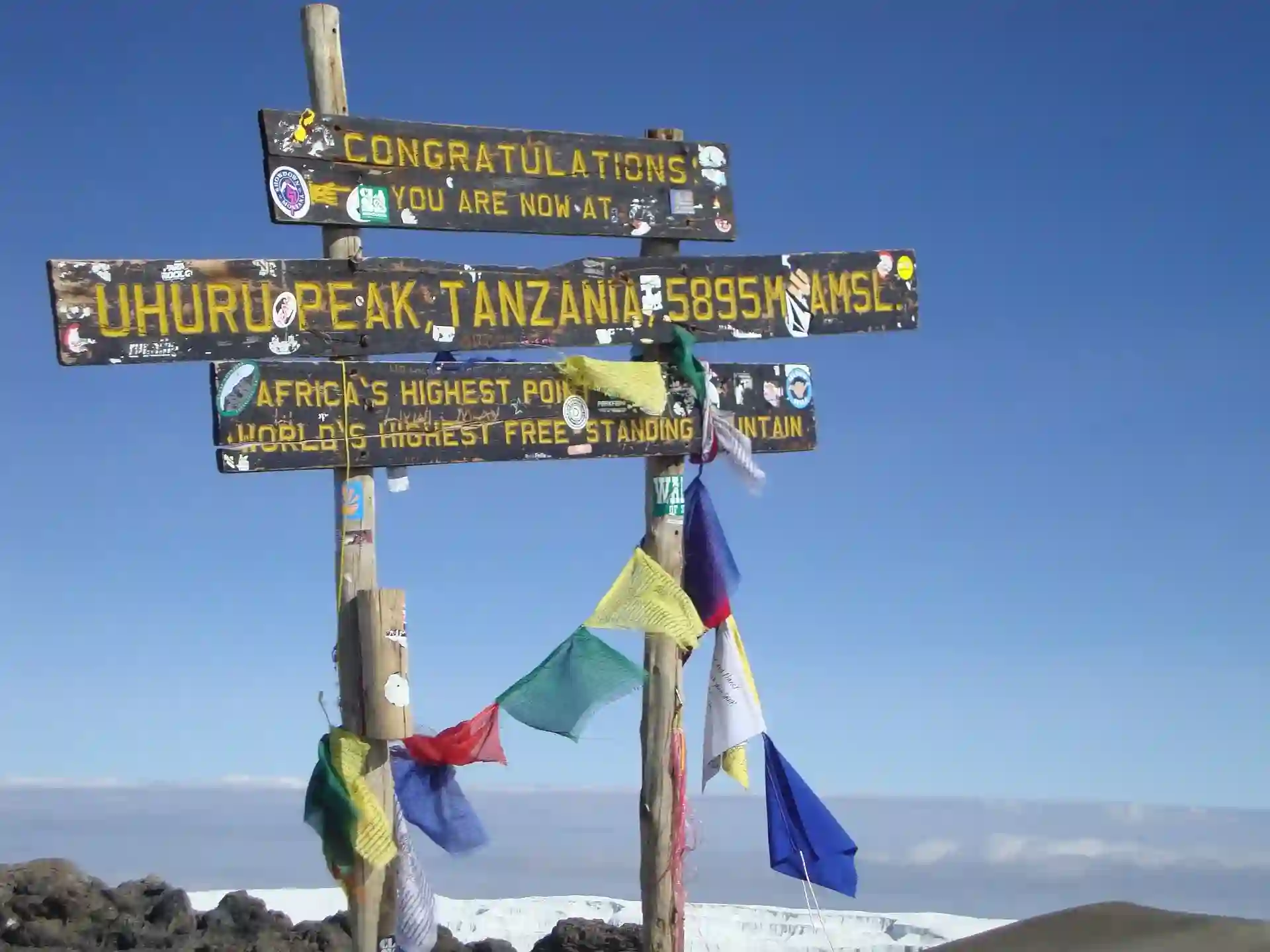
The final ascent usually begins at night from Barafu Camp, Kibo Hut or School Hut. Climbers move slowly by headtorch over steep volcanic ground towards the crater rim. Depending on the approach, the first major rim point may be Stella Point or Gilman’s Point; Uhuru Peak is the highest point at 5,895 metres.
What the Summit Landscape Contains
- Loose volcanic scree and rock
- The crater rim and inner crater
- Seasonal snow or ice on the trail
- Remnant glaciers and ice cliffs
- Almost no visible vegetation
- Vast views over the plains when conditions are clear
Kilimanjaro’s glaciers are visually extraordinary but vulnerable. UNESCO identifies glacier retreat as a feature of particular concern in relation to climate change. Their presence does not mean that the trekking trail is always covered in deep snow; surface conditions vary with recent weather and season.
Standard trekking routes do not require climbers to travel across the glaciers. Do not leave the established trail to approach ice formations.
Why Summit Night Feels So Severe
Temperatures are below freezing, wind increases heat loss and the climb takes place during the coldest hours of the night. Oxygen pressure near the summit is roughly half its sea-level value. Climbers are also moving slowly and carrying fatigue from several days of trekking.
Water bottles, hydration hoses and batteries may freeze. The sunrise can transform the atmosphere, but wind and shade remain significant and the descent still requires concentration.
Summit Clothing System
A typical system includes:
- Thermal base layers for upper and lower body
- Fleece or warm mid-layer
- Substantial insulated jacket
- Waterproof and windproof outer layers
- Warm beanie or balaclava
- Neck gaiter or face covering
- Liner gloves and insulated outer gloves or mittens
- Warm trekking socks without compressing the feet
- Broken-in waterproof boots
- Headtorch worn securely over the head covering
Fit matters. Excessive sock layers can make boots tight and reduce circulation.
The Summit Is a Brief Visit
Humans do not fully acclimatise to Kilimanjaro’s summit during a normal itinerary. Climbers reach the high point, take limited time for photographs and descend to a much lower camp on the same day.
Reaching the sign is not more important than safety. A guide may turn a climber around for worsening altitude symptoms, severe cold, exhaustion, poor coordination, dangerous weather or inability to maintain a safe pace.
How the Zones Differ by Route
Every standard route passes through the same broad progression, but not every route shows each zone in the same way.
Lemosho and Machame
These western and southern approaches generally feature lush forest, an open traverse across the Shira area and varied heath and moorland scenery. They later cross alpine-desert terrain around Lava Tower and the southern circuit before approaching Barafu.
Northern Circuit
The route begins on the western side and travels around the quieter northern slopes. The moisture gradient becomes apparent: after the greener west, sections of the north feel drier and more open.
Rongai
Rongai approaches from the north. Its lower environment is generally drier than the southern routes, and forest vegetation may be less dense. The route later passes near Mawenzi before joining the summit approach from Kibo.
Marangu
Marangu climbs through south-eastern montane forest, continues across open moorland around Horombo and enters the alpine desert towards Kibo Hut. Hut accommodation changes the overnight experience but not the climate outside.
Umbwe
Umbwe rises steeply through dense southern forest and reaches higher open terrain quickly. Its dramatic ecological transition also reflects an aggressive altitude profile, so it is not usually our recommendation for an unacclimatised first-time high-altitude climber.
Route choice should consider more than vegetation. Itinerary length, sleeping-altitude progression, crowding, scenery, descent route and experience all matter.
The Descent: Five Zones in Reverse
After the summit, climbers descend remarkably quickly. Someone who stood among ice and bare rock in the morning may be back among giant heather that afternoon and inside humid forest the next day.
Most southern itineraries descend via Mweka, while Marangu returns along its own corridor. As elevation falls, breathing usually becomes easier, temperatures rise and vegetation rapidly returns. Loose summit scree gives way to rock, moorland paths, roots and mud.
Do not pack all rainwear into the porter duffel because summit morning is clear. The descent trail can be wet and slippery, and waterproofs should remain in the daypack until the final gate.
Clothing Strategy Across All Five Zones
Kilimanjaro does not require five separate wardrobes. It requires layers that work together.
- Base layer: Moves moisture away from the skin. Use synthetic or merino fabrics rather than cotton.
- Mid-layer: Adds breathable insulation. A fleece is useful from the moorland upwards.
- Insulated layer: Provides substantial warmth at high camps, stops and on summit night.
- Shell layer: Blocks rain and wind. Bring a waterproof jacket and overtrousers even in a drier season.
- Accessories: Sun hat, warm hat, neck gaiter, liner gloves, insulated gloves, sunglasses and dry socks allow small adjustments.
For detailed temperature ranges and clothing combinations, see our Kilimanjaro temperature and clothing guide. For the full equipment list, use our Kilimanjaro packing list.
What to Keep in Your Daypack
Porters normally carry the main duffel between camps. You may not have access to it during the trekking day, so changing zones must be managed from your daypack.
Keep these items accessible:
- Waterproof jacket and overtrousers
- Fleece or light insulating layer
- Warm hat and gloves
- Sun hat, sunglasses and sunscreen
- Water and snacks
- Personal medication
- Pack liner or dry bags
- Camera or phone protected from rain and cold
- Trekking poles when not in use
The forecast may be dry, but Kilimanjaro creates local weather. Pack for conditions that could develop, not only those visible at breakfast.
Climate Zones and Altitude Sickness Are Different Subjects
The environmental zones make altitude change visible, but they do not diagnose acclimatisation. There is no altitude at which every climber becomes sick, and no zone in which everyone is safe.
Symptoms often become more noticeable in the moorland or alpine desert because sleeping altitude is increasing. Warning signs include headache, nausea, dizziness, vomiting, unusual fatigue, reduced walking performance, confusion, loss of coordination and breathlessness at rest.
Never hide symptoms to protect a summit attempt. Read our Kilimanjaro acclimatisation and altitude-sickness guide before choosing an itinerary.
How to Protect Kilimanjaro’s Environments
Crossing so many ecosystems in a few days is a privilege. Small actions by thousands of visitors can create large impacts.
- Stay on established paths rather than cutting switchbacks.
- Do not pick flowers or remove rocks, plants or ice.
- Never feed monkeys, birds or other wildlife.
- Keep a respectful distance from animals.
- Pack out personal litter, including wipes and snack wrappers.
- Use toilets and sanitation systems as instructed.
- Keep soap and chemicals away from natural water sources.
- Avoid trampling fragile alpine plants for photographs.
- Follow guides and park regulations around camps and trails.
Plants in the upper zones grow extremely slowly. A footprint that appears minor may damage vegetation that has taken years to establish.
Frequently Asked Questions
Does Kilimanjaro officially have five climate zones?
UNESCO identifies five main vegetation zones: lower slopes, montane forest, heath and moorland, alpine desert and summit. “Five climate zones” is the common trekking description. Scientific studies may divide or name vegetation belts more precisely.
Are the elevation boundaries exact?
No. The boundaries are approximate. Vegetation shifts with slope direction, rainfall, soil, exposure and human land use, so zones overlap and begin at different heights.
Which zone receives the most rain?
The montane forest is generally the wettest zone encountered by climbers. Southern and south-eastern slopes usually receive more moisture than the northern side, but rain is possible on every route.
Which zone is the coldest?
The arctic summit zone is the coldest. Summit attempts normally take place before dawn, combining sub-zero temperatures, wind, darkness and extreme altitude.
Which zone has the most wildlife?
The montane forest supports the greatest visible variety on standard trails. Monkeys and birds may be seen, but sightings are not guaranteed. Larger mammals tend to be elusive or away from busy routes.
Where do giant groundsels and lobelias grow?
They are associated with the heath and moorland, especially suitable moist or sheltered locations. Their distribution differs by route and habitat.
Does every route cross all five zones?
Every standard ascent moves through the same broad sequence, although some trailheads begin near the upper edge of the cultivated lower slopes and each route displays the zones differently.
Is Rongai less scenic because it is drier?
No. It is different rather than inherently less scenic. Its drier northern landscapes offer open views and a quieter feeling, while southern and western routes generally provide lusher forest.
Is there always snow in the summit zone?
Glaciers and permanent ice features remain, but snow on the trekking path varies with recent weather. Prepare for snow, ice and severe cold without assuming deep snow will always be present.
In which zone does altitude sickness begin?
There is no fixed zone. Symptoms can appear after a rapid ascent to any sufficiently high elevation and often become noticeable from the moorland upwards.
Can one clothing system work across all five zones?
Yes. A modular system of wicking base layers, fleece, insulation and waterproof-windproof shells lets you add or remove warmth as conditions change.
Which route shows the greatest variety?
All routes are varied. Longer Lemosho and Northern Circuit itineraries expose climbers to western, southern and northern landscapes, while Machame also presents a dramatic progression. The best route depends on acclimatisation, time and personal priorities as well as scenery.
Experience Kilimanjaro’s Full Vertical Journey
The five zones are part of what makes Kilimanjaro unlike almost any other trek. Yet the most beautiful route is not automatically the best itinerary for every climber. The number of days, camp sequence, acclimatisation opportunities, season and group needs should guide the decision.
At Tanzania Inside Safari, we help climbers choose a route that balances scenery with a responsible ascent profile. Our local team explains what to expect in each environment, checks equipment before departure and manages pace, health monitoring and safety throughout the climb.
Tell us your preferred travel dates, available days, group size and previous altitude experience. We will recommend a Kilimanjaro itinerary suited to your goals.