


How Mount Kilimanjaro Was Formed: Kibo, Mawenzi and Shira Explained
Discover how Mount Kilimanjaro formed, why it has three volcanic centres and what Kibo, Mawenzi and Shira reveal to climbers today.

Kilimanjaro’s Geology at a Glance
Mount Kilimanjaro looks like a single enormous mountain when viewed from the plains of northern Tanzania. Geologically, however, it is more complex. Kilimanjaro is a volcanic massif built from three overlapping volcanic centres: Shira in the west, Kibo in the middle and Mawenzi in the east.
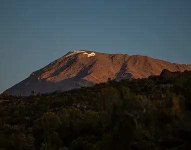
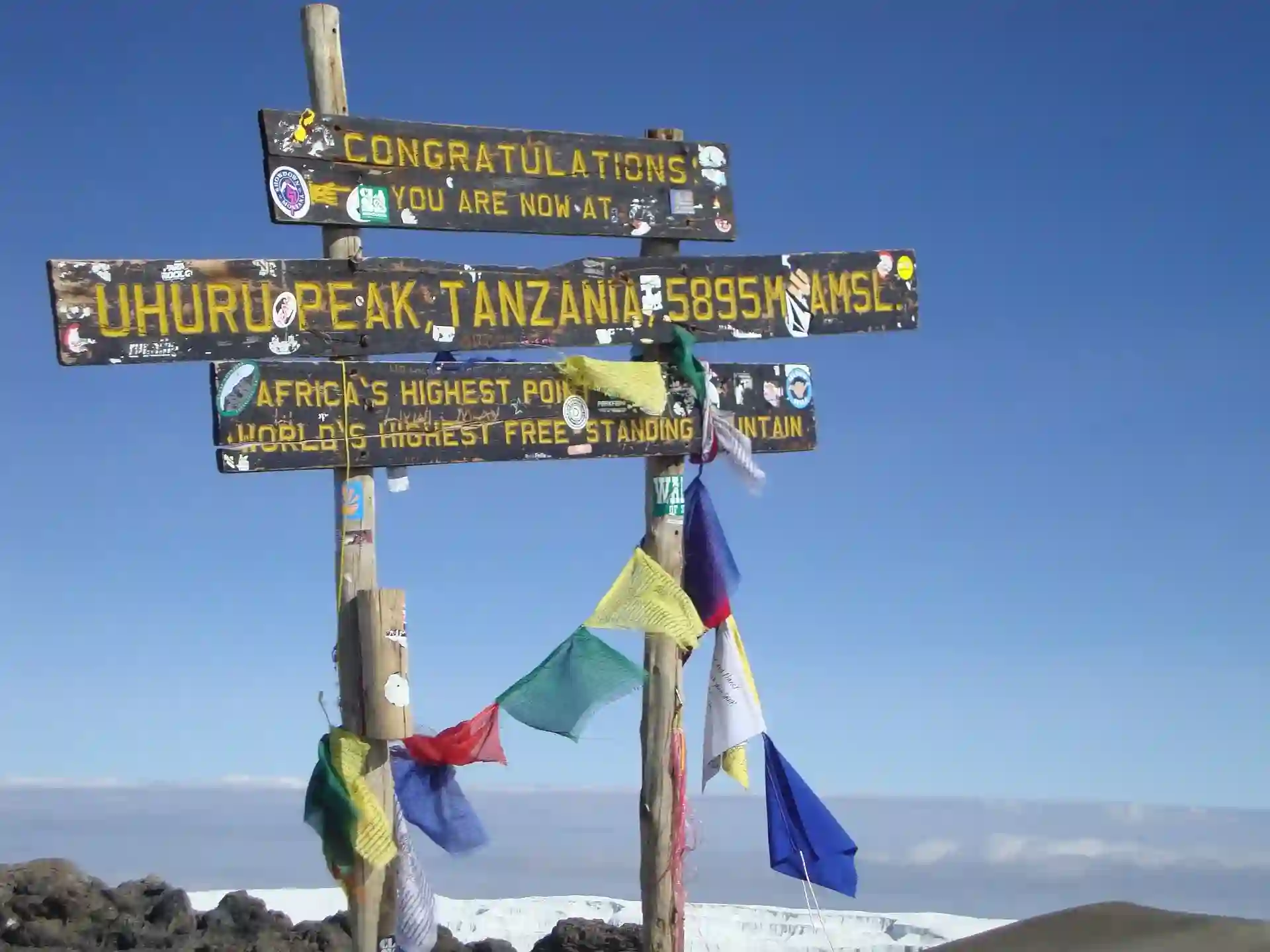
These centres did not form at exactly the same time or develop in the same way. Shira is the oldest and has been deeply eroded. Mawenzi came later and now appears as a rugged collection of pinnacles and ridges. Kibo is the youngest, highest and best-preserved centre. Uhuru Peak, the 5,895-metre summit reached by trekkers, stands on Kibo’s crater rim.
The mountain’s present shape records millions of years of activity. Repeated lava flows and explosive eruptions built its slopes. Structural collapse, tropical rain, glaciers, wind and freeze-thaw weathering then cut into them. The result is not only Africa’s highest mountain but a landscape in which climbers can walk across the remains of several stages of volcanic construction and destruction.
- Kilimanjaro is an overlapping volcanic massif rather than one simple cone.
- Its three main volcanic centres are Shira, Mawenzi and Kibo.
- Volcanic construction began approximately 2.5 million years ago.
- Shira is the oldest centre, Mawenzi developed later and Kibo is the youngest.
- Uhuru Peak is on the southern rim of Kibo’s summit area.
- Shira and Mawenzi are deeply eroded and are generally regarded as long inactive.
- Kibo retains a recognisable crater system and limited geothermal signs.
- No historical eruption has been documented, and the Smithsonian Global Volcanism Program lists no confirmed Holocene eruption for Kilimanjaro.
- The mountain formed in association with the tectonic stretching of the East African Rift system.
- Climbers can see volcanic plateaux, lava ridges, crater rims, plugs, ash and erosion features on several routes.
Kilimanjaro Is Three Volcanic Centres, Not Three Separate Mountains
Kibo, Mawenzi and Shira are sometimes called Kilimanjaro’s three volcanic cones. This is useful shorthand, but it can suggest three completely separate volcanoes standing beside one another.
In reality, their lava flows and other volcanic deposits overlap to form one broad massif. The entire volcanic structure is roughly elliptical and extends for tens of kilometres across northern Tanzania. Each centre had its own vents and phases of activity, but later eruptions partly covered or joined older terrain.
From west to east, the centres are arranged as:
- Shira, the oldest and most eroded centre
- Kibo, the youngest, highest and most symmetrical centre
- Mawenzi, an older and deeply dissected centre east of Kibo
This west-to-east list describes their present position, not their formation order. The broad geological sequence is Shira first, followed by Mawenzi and then Kibo, although activity overlapped and the detailed history contains many separate eruptive phases.
Why Did a Volcano Form Here?
Kilimanjaro stands near the eastern branch of the East African Rift system. This is a vast tectonic region where forces within the Earth are gradually stretching and thinning the continental crust.
Rifting does not simply split a continent in one clean line. It produces networks of faults, fractures and subsiding basins. Changes in pressure beneath the crust can generate magma, while fractures create pathways through which that magma can rise.
In northern Tanzania, this process helped produce several major volcanoes, including Kilimanjaro, Mount Meru and volcanoes farther west in the Ngorongoro highlands. They are related to the wider tectonic setting, but they did not all form simultaneously or from one shared surface vent.
At Kilimanjaro, repeated eruptions brought lava, ash and fragmented volcanic material to the surface. Layer after layer accumulated, gradually constructing an enormous mountain above the surrounding plains.
How Volcanic Mountains Grow
A volcano the size of Kilimanjaro is not created by one eruption. It develops through many eruptive episodes separated by quieter periods that may last thousands of years.
During relatively fluid eruptions, lava travels away from a vent and cools into solid rock. Repeated flows broaden and raise the mountain. More explosive activity can eject ash, blocks and other broken material. Smaller vents may open on the flanks, building secondary cones or feeding additional lava flows.
The composition and behaviour of the magma can change over time. Geological studies of Kilimanjaro identify a range of volcanic rocks, from relatively basaltic early lavas to more chemically evolved rocks such as trachytes and phonolites. For a trekker, the important point is that Kilimanjaro was built through multiple styles and stages of activity rather than as a uniform pile of identical lava.
Construction is only half the story. While eruptions build a volcano, weather and gravity begin taking it apart. Streams carve gullies, rock faces collapse, glaciers erode the upper slopes and daily freezing and thawing loosen exposed rock. Older volcanic centres therefore tend to look more irregular than younger, better-preserved ones.
Shira: The Oldest Volcanic Centre
Shira occupies the western side of Kilimanjaro. Geological dating indicates that volcanic activity here began approximately 2.5 million years ago, making it the oldest of the three principal centres. Important phases of Shira’s construction continued later, but its original cone has long since lost the clean outline it once possessed.
Today, climbers approaching on the Lemosho or Shira routes encounter the broad Shira Plateau. This high landscape is often described as the floor or remnant of an ancient caldera. Its form reflects a combination of volcanic collapse, prolonged erosion and modification by later deposits from Kibo.
Shira’s highest surviving point is commonly given as approximately 3,962 metres. That is far below the height of Kibo, but it should not be assumed that the original Shira volcano was always this low. Much of its former structure has been removed or buried.
What Happened to Shira’s Original Cone?
As Shira’s activity declined, its summit structure was weakened and reshaped. Collapse affected the central area, while erosion progressively cut into its flanks. Later lava from the growing Kibo centre spread towards and across parts of the older terrain.
The result is a broad, complex plateau edged by ridges rather than a sharp summit cone. Features such as the Shira Cathedral and surrounding ridgelines are remnants within this ancient volcanic landscape.
It is tempting to describe Shira as a volcano that simply “collapsed and became a plateau.” That is too neat. Its modern appearance reflects several processes operating over a long period: volcanic construction, structural failure, burial by younger material and extensive erosion.
What Climbers See at Shira
On a clear day, the contrast between the plateau and Kibo is striking. Climbers stand within old, weathered volcanic terrain while the much younger central cone rises ahead.
The western approaches may reveal:
- Wide expanses of the Shira Plateau
- Resistant ridges and rocky outcrops
- Old lava surfaces altered by weathering
- Views across the remains of the Shira volcanic centre
- Younger Kibo deposits overlapping the older landscape
The plateau therefore provides one of the clearest places to understand that Kilimanjaro was assembled in stages.
Mawenzi: The Jagged Eastern Peak
Mawenzi rises east of Kibo and reaches approximately 5,149 metres. It is Kilimanjaro’s second-highest summit and one of the mountain’s most distinctive features.
Unlike Kibo’s relatively smooth upper cone, Mawenzi is a dramatic collection of dark towers, steep gullies and broken ridges. This appearance does not mean that Mawenzi formed as a naturally jagged cluster. It is largely the result of deep erosion acting on an older volcanic centre.
Mawenzi developed after Shira. Geological dating shows that some of its later volcanic rocks are roughly 450,000 years old. Since then, weathering and erosion have stripped away much of the cone’s less-resistant material.
Why Is Mawenzi So Jagged?
Volcanic cones contain rocks with different strengths. Some lava and solidified material within old conduits resist erosion better than loose ash, fractured rock or weaker surrounding layers.
As water, ice, wind and temperature changes attacked Mawenzi, softer material was removed more quickly. Harder internal structures remained standing as pinnacles, ribs and buttresses. The mountain now exposes part of the framework that once lay inside a more complete cone.
Several processes continue to shape Mawenzi:
- Rain and runoff cut gullies into the slopes.
- Freeze-thaw cycles widen cracks at high altitude.
- Gravity pulls loosened blocks down steep faces.
- Past glaciers and permanent snowfields helped excavate upper valleys.
- Wind removes fine material and contributes to surface weathering.
This rugged terrain is unstable in places. Reaching Mawenzi’s highest point is a technical mountaineering objective and is not part of a standard Kilimanjaro trek. Ordinary climbers view the peak from established trails and camps rather than attempting its pinnacles.
Mawenzi Tarn and the Eastern Routes
The Rongai Route offers particularly strong views of Mawenzi. Some itineraries visit or camp near Mawenzi Tarn, a small lake lying beneath the peak’s cliffs. From this area, the effects of erosion are much easier to appreciate than they are from the distant plains.
Marangu climbers also gain changing views of Mawenzi as they cross the eastern side of the massif. The peak dominates the horizon before the trail turns towards Kibo.
Kibo: The Youngest and Highest Centre
Kibo is the great central cone and the youngest of Kilimanjaro’s main volcanic centres. It rises to 5,895 metres at Uhuru Peak, making it the highest point in Africa.
Its younger age helps explain why Kibo appears more complete and symmetrical than Mawenzi or Shira. Erosion has certainly altered it, but it has not had as much time to dismantle the main structure.
Kibo grew through repeated lava flows and eruptions from summit and flank vents. Its deposits spread over parts of the older Shira and Mawenzi landscapes, joining the separate volcanic centres into the massif seen today.
Is Uhuru Peak the Top of a Volcanic Cone?
Uhuru Peak is not a pointed central vent. It stands on the southern rim of Kibo’s summit area.
When trekkers approach from Stella Point or Gilman’s Point, they are moving around part of that rim. The broad high summit landscape contains nested volcanic features rather than one simple bowl.
Kibo’s summit complex includes:
- An outer caldera or crater-rim structure
- The inner Reusch Crater
- The Ash Pit within the central summit area
- Ice fields and remnant glaciers around parts of the rim
- Lava, ash and weathered volcanic deposits
The terminology can be confusing because different maps and publications use “Kibo Crater,” “caldera,” “Reusch Crater” and “Ash Pit” at different scales. The simplest distinction is that the summit contains a large outer depression, a smaller inner crater and a deeper central pit.
Most standard summit itineraries go to Uhuru Peak and then descend. They do not automatically enter the inner crater. Crater-camp itineraries require additional planning, appropriate permits and careful consideration of the prolonged exposure above 5,500 metres.
The Saddle Between Kibo and Mawenzi
The Saddle is the broad, high-altitude expanse separating Kibo from Mawenzi. Climbers on the Rongai and Marangu approaches cross or overlook it before reaching Kibo.
It is sometimes introduced as empty ground between two volcanoes, but its geology is more interesting. Lava and other volcanic deposits from the growing centres helped construct and fill this connecting area. Erosion and the cold, dry high-altitude climate later shaped its present surface.
The Saddle makes the contrast between the two centres especially clear: jagged, eroded Mawenzi stands on one side, while the smoother, younger cone of Kibo rises on the other.
Vegetation is sparse because of the altitude, cold, dryness and strong solar radiation. The openness exposes climbers to wind and large changes between daytime warmth and night-time cold.
Calderas, Craters and Collapse
The terms crater and caldera are often used interchangeably in travel writing, but they describe different scales of volcanic depression.
A crater is generally a depression around a volcanic vent. A caldera is a much larger structure, often created when part of a volcano collapses after magma is withdrawn or after major eruptive activity changes the support beneath the summit.
Kilimanjaro contains features formed by both eruption and collapse. Shira’s broad remnant landscape is associated with the destruction and erosion of an older summit structure. Kibo preserves a younger nested crater system. Smaller pits, vents and flank cones record additional pathways through which magma once reached the surface.
These features should not be interpreted as proof that one giant explosion produced the whole mountain. Kilimanjaro’s geology represents a long sequence of construction, collapse, renewed eruption and erosion.
Is Kilimanjaro Active, Dormant or Extinct?
Travel sources often state that Shira and Mawenzi are extinct while Kibo is dormant. This is a reasonable general summary, but volcanic labels require care.
Shira and Mawenzi are deeply eroded and show no evidence of recent eruptive activity. Kibo is younger, retains a well-defined crater system and has limited geothermal or fumarolic signs in the summit area. For those reasons, Kibo is commonly described as dormant rather than extinct.
However, “dormant” does not mean that an eruption is expected soon. No eruption has been recorded in Kilimanjaro’s written history. More importantly, the Smithsonian Institution’s Global Volcanism Program states that it is not aware of any confirmed Holocene eruptions from Kilimanjaro. The Holocene covers approximately the last 11,700 years.
This matters because some popular articles repeat claims that Kilimanjaro erupted a few hundred or a few thousand years ago. Those claims should not be presented as established fact without robust geological evidence.
The most accurate practical summary is:
- Kilimanjaro is a geologically young volcanic massif.
- Kibo is commonly classified as dormant or potentially active over geological time.
- There is no documented historical eruption.
- There is no evidence that an eruption is imminent.
- Eruption is not a routine hazard faced by present-day trekkers.
Scientists cannot promise that a volcano will never erupt again. Volcanic systems can remain quiet for extremely long periods. Any modern assessment would depend on monitoring for changes such as earthquake swarms, ground deformation, gas emissions or unusual heat flow.
When Did Kilimanjaro Last Erupt?
There is no single, securely established “last eruption date” that should be quoted as though it were a witnessed event.
Geologists reconstruct Kilimanjaro’s history by dating lava and other material, mapping which deposits lie above or below others and studying the mountain’s landforms. Different parts of the massif were active at different times, and not every small eruptive deposit can be dated precisely.
Research clearly establishes that the main volcanic construction occurred during the Pleistocene. Shira began forming around 2.5 million years ago, later activity developed Mawenzi and Kibo became the youngest main centre. But a popular claim such as “the last eruption occurred 200 years ago” is not supported by the recognised eruption record.
For climbers, the uncertainty does not create a special reason for alarm. The immediate mountain risks are altitude illness, cold, fatigue, falls, severe weather and rockfall—not lava or ash from an expected eruption.
How Erosion Created the Mountain Climbers See Today
Volcanic activity supplied Kilimanjaro’s raw structure, but erosion created much of its present character.
Tropical Rainfall
Moist air rises against the mountain and produces substantial rainfall on lower and middle slopes, particularly on the south and east. Streams cut valleys through old lava and loose volcanic deposits. Dense forest and soil may hide the rock, but the drainage pattern reflects the volcanic foundation beneath it.
Glaciers and Past Ice
Kilimanjaro’s glaciers are now restricted to the upper mountain, but colder periods supported more extensive ice. Glacial movement helped widen valleys, scour rock and transport debris. Evidence of former glaciation extends beyond the ice seen by climbers today.
Freeze-Thaw Weathering
Water entering cracks can freeze and expand. Repeated freezing and thawing weaken exposed rock, especially on steep high-altitude faces. This contributes to the fractured terrain of Mawenzi and rockfall hazards elsewhere.
Wind and Temperature Change
Strong wind carries dust and fine particles across the alpine desert. Intense sunlight can warm exposed rock during the day, followed by severe cooling at night. These cycles add stress to already fractured surfaces.
Gravity
Once weathering loosens rock, gravity moves it downhill. Scree slopes, isolated boulders and debris fans are therefore part of the mountain’s continuing geological development.
Kilimanjaro may appear permanent during a week-long trek, but it is still changing. Most changes are gradual; occasional rockfalls, landslides or debris movements make that slow process visible.
Volcanic Features Climbers May Recognise
You do not need to be a geologist to read some of Kilimanjaro’s landscape.
Lava Tower
Lava Tower, visited on many Machame and Lemosho itineraries, is a resistant volcanic rock formation on Kibo’s western side. It is commonly interpreted as a remnant associated with old volcanic plumbing or a resistant intrusive feature left standing as surrounding material eroded.
It also serves an important acclimatisation role: many trekkers climb towards Lava Tower and then descend to sleep at Barranco.
Shira Plateau
The plateau represents the deeply altered remains of the oldest volcanic centre. Its broad scale is easier to understand while crossing it than from a distant viewpoint.
Barranco Valley and Wall
The southern side of Kibo contains deeply cut valleys, lava ridges and steep rock steps. Barranco Wall forms part of this eroded volcanic terrain. Despite its dramatic appearance, the standard ascent is a steep scramble rather than a technical rock climb in normal conditions.
The Western Breach
The Western Breach is a major break in Kibo’s western crater wall. Its steep channels and loose rock reveal how collapse and erosion have modified the summit structure. The route through it carries significant rockfall exposure and is not comparable to the normal summit paths.
Gilman’s Point, Stella Point and Uhuru Peak
These named points sit on Kibo’s rim. Gilman’s Point is on the eastern side, Stella Point lies farther south-west and Uhuru Peak occupies the highest part of the southern rim. Moving between them gives climbers an unusual perspective across the summit structure.
Flank Cones and Lava Ridges
Smaller cones and vents occur around the massif. Some are subtle and may look like ordinary hills. They record eruptions that did not come directly from the central summit vent.
Which Route Shows Kilimanjaro’s Geology Best?
Every route crosses volcanic ground, but each reveals a different part of the massif.
Lemosho Route
Lemosho is one of the strongest choices for seeing the transition from Shira’s ancient landscape to Kibo. It approaches from the west, crosses the Shira Plateau and normally continues past Lava Tower before traversing the southern slopes.
Shira Route
The Shira Route begins high on the western side and reaches the plateau quickly. It provides extensive views of the Shira centre, although its high starting elevation gives less time for gradual acclimatisation than Lemosho.
Northern Circuit
The Northern Circuit begins through the western landscape and then travels around Kibo’s quieter northern slopes. Its length provides changing views of lava ridges, dry valleys and the relationship between the main cone and its flanks.
Machame Route
Machame offers an excellent sequence of volcanic features, including views across the Shira area, Lava Tower, the Barranco landscape and Kibo’s southern side.
Rongai Route
Rongai provides the closest standard trekking relationship with Mawenzi. Depending on the itinerary, climbers may visit Mawenzi Tarn before crossing the Saddle towards Kibo.
Marangu Route
Marangu approaches between Mawenzi and Kibo, crosses the Saddle and reaches the eastern crater rim at Gilman’s Point. It clearly demonstrates the contrast between the eroded older peak and the younger central cone.
Umbwe Route
Umbwe rises steeply through deeply incised southern terrain before joining the southern circuit. It gives a powerful sense of the mountain’s relief, but its rapid altitude gain makes it suitable only for carefully selected itineraries.
No route should be chosen on scenery or geology alone. Acclimatisation profile, number of days, season, experience and personal objectives remain more important.
Does Kilimanjaro’s Geology Affect Climbing Conditions?
Yes. The mountain’s volcanic origin influences the ground underfoot and the shape of the trails.
Climbers encounter:
- Mud and roots over weathered volcanic soil in the rainforest
- Firm lava surfaces and rocky ridges
- Loose scree and ash on the upper cone
- Large boulders and steep rock steps
- Eroded gullies that channel water, ice or falling debris
Summit slopes often contain loose material that slides beneath the boots. This makes progress tiring even where the gradient is not technically difficult. Trekking poles and deliberate pacing can help, especially during the descent.
Steep volcanic faces also create rockfall risk. Climbers should follow their guide’s instructions, avoid dislodging stones and keep appropriate spacing in exposed terrain.
Can Climbers Visit Kibo’s Crater?
Some specialist itineraries include Kibo Crater Camp, but it is not part of most climbs.
Sleeping near 5,700 metres creates a much greater altitude burden than descending soon after reaching Uhuru Peak. A crater itinerary therefore requires sufficient acclimatisation, an experienced operator, suitable weather and a clear safety plan.
The crater should not be treated as a casual extension added for photographs. A climber who develops worsening altitude symptoms must descend, regardless of the itinerary.
Visitors must also remain on permitted routes and follow Kilimanjaro National Park regulations. Entering unstable or restricted areas, approaching fumaroles without authority or collecting volcanic rocks is inappropriate and potentially dangerous.
How Scientists Reconstruct Kilimanjaro’s History
No human watched Shira begin to grow 2.5 million years ago. Scientists reconstruct the sequence using several complementary methods.
Radiometric Dating
Radioactive isotopes decay at known rates. Measuring particular isotopes in volcanic rock can indicate when the material cooled and solidified. Potassium-argon dating has been especially important in establishing the ages of Kilimanjaro’s lava sequences.
Geological Mapping
Researchers map lava flows, ash layers, vents, faults and erosional surfaces. Where one deposit covers another, the upper layer is normally younger.
Rock Chemistry
Chemical analysis helps distinguish magma batches and reveals how magma evolved underground. It can also connect separated exposures that formed during related phases.
Landform Analysis
The form of valleys, crater rims, plateaux and glacial features helps explain what occurred after eruptions ended. Satellite imagery and digital elevation models allow scientists to examine structures across the whole massif.
Field Observation
Direct study remains essential. Researchers collect carefully documented samples, measure exposed layers and compare the rocks on different sides of the mountain.
Scientific interpretations may be refined as new dates and mapping become available. That is why responsible descriptions distinguish established evidence from attractive but unverified stories.
Three Common Misunderstandings
“Kilimanjaro Is One Volcano”
Kilimanjaro is one connected massif, but it contains three principal volcanic centres with different ages and histories.
“The Three Peaks All Look Like Kibo”
They probably once looked more alike than they do now, but age and erosion have produced very different forms. Shira is reduced to a broad remnant landscape, Mawenzi is deeply dissected and Kibo retains a comparatively complete cone.
“Dormant Means an Eruption Is Due”
Volcanoes do not erupt on a human timetable. Describing Kibo as dormant acknowledges its geological character; it does not predict an approaching eruption. There is currently no established evidence of imminent activity.
Frequently Asked Questions
Is Mount Kilimanjaro one volcano or three?
It is one large volcanic massif formed from three main overlapping centres: Shira, Mawenzi and Kibo.
Which part of Kilimanjaro formed first?
Shira is the oldest principal centre. Volcanic activity there began approximately 2.5 million years ago. Mawenzi developed later, and Kibo is the youngest main centre.
Which of Kilimanjaro’s three peaks is highest?
Kibo is highest. Uhuru Peak, on Kibo’s rim, reaches 5,895 metres. Mawenzi reaches approximately 5,149 metres, while Shira’s highest surviving point is commonly listed at approximately 3,962 metres.
Is Uhuru Peak a separate volcano?
No. Uhuru Peak is the highest point on Kibo, the central and youngest volcanic centre.
Why is Mawenzi jagged?
Long-term erosion removed weaker material and exposed more resistant rock within the old volcanic structure. Freeze-thaw weathering, water, wind and rockfall continue to shape it.
What happened to Shira?
Shira’s original cone was affected by collapse, erosion and burial by younger deposits. What remains includes the broad Shira Plateau and surrounding ridges.
Is Kibo an active volcano?
Kibo is commonly described as dormant because it is the youngest centre and retains a crater system with limited geothermal signs. There is no documented historical eruption and no evidence that an eruption is imminent.
When did Kilimanjaro last erupt?
There is no securely established recent eruption date. The Smithsonian Global Volcanism Program recognises no confirmed Holocene eruption from Kilimanjaro, so claims of an eruption only a few hundred years ago should be treated cautiously.
Could Kilimanjaro erupt again?
It cannot be ruled out over geological time, but there is no current evidence of an imminent eruption. Volcanic activity is not a normal risk for present-day trekkers.
What is the Saddle?
The Saddle is the broad high-altitude landscape between Mawenzi and Kibo. It is formed from overlapping volcanic deposits subsequently modified by erosion.
What is inside Kibo’s summit?
Kibo has a nested summit complex that includes an outer crater or caldera structure, Reusch Crater and the Ash Pit.
Do normal Kilimanjaro climbs enter the crater?
No. Standard itineraries reach Uhuru Peak and descend. Crater visits require specialist planning and involve prolonged exposure at extreme altitude.
Can trekkers climb Mawenzi?
Not on a standard trek. Mawenzi is technical, steep and affected by loose rock. Its climbing is restricted and requires different skills and authorisation.
Which route is best for seeing Shira?
Lemosho and Shira give the most direct experience of the Shira Plateau. The Northern Circuit also begins through this western landscape.
Which route gives the best views of Mawenzi?
Rongai is especially good for close Mawenzi views and can include Mawenzi Tarn. Marangu also provides strong views before crossing towards Kibo.
Are the rocks safe to collect?
No. Kilimanjaro lies within a protected national park. Leave rocks, plants and other natural material where they are.
Walking Through Kilimanjaro’s Geological Story
Understanding the mountain’s formation changes the way a climb feels. The Shira Plateau is no longer simply an open campsite area; it is part of the oldest centre. Mawenzi’s spires become the eroded interior of a once larger volcano. The long approach to Kibo crosses deposits that joined those older centres, and the final steps to Uhuru Peak follow the rim of the youngest summit complex.
At Tanzania Inside Safari, our guides help climbers understand the landscapes they pass through while keeping the climb focused on safe pacing, acclimatisation and responsible travel. Route choice determines not only the number of days and altitude profile but also which chapters of Kilimanjaro’s natural history you see most clearly.
Tell us which scenery interests you, how much high-altitude experience you have and how many days you can allow. We will help you choose an itinerary that balances geological variety with a responsible ascent.